Ideal use for trek, trekking, hike, hiking, bike, biking and cycling with offline map.
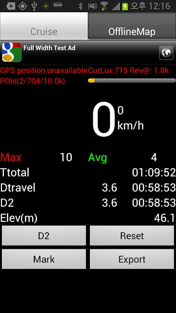
Using GPS, it can show current speed and distance traveled. Overlaying current positions and target tracks in the map.
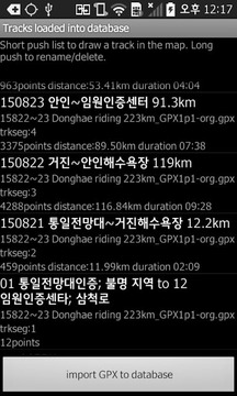
GPX exporting for drawing your path in the Google earth or built in map. http://utrack.crempa.net/ is a good program for analyze your tracks with altitude and speed. For this, you need to make sure to export tracks recorded as "Track" button when you exporting GPX since the website doesn't accept waypoint-based GPX file. http://www.routeconverter.de/home/en is also a quite good program too for having comprehensive capability of dealing with every GPX files.
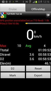
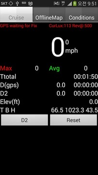
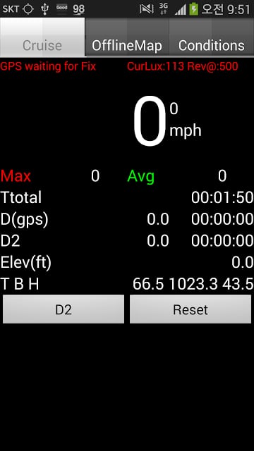
In navigation pane, you can see current positions and distance traveled. You can change Font size dynamically fiting for the best view in your target device. Background/fore ground color can be changed in automatically adjusted with light sensor. Or you can fix it.
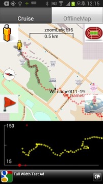
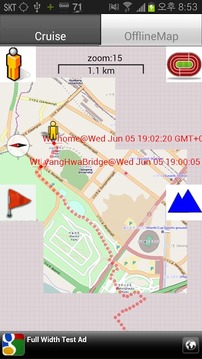
Off-line map pane without requiring Internet connection.
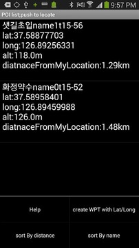
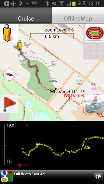
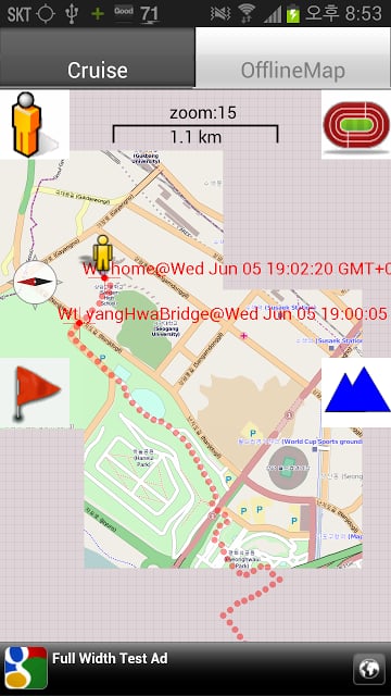
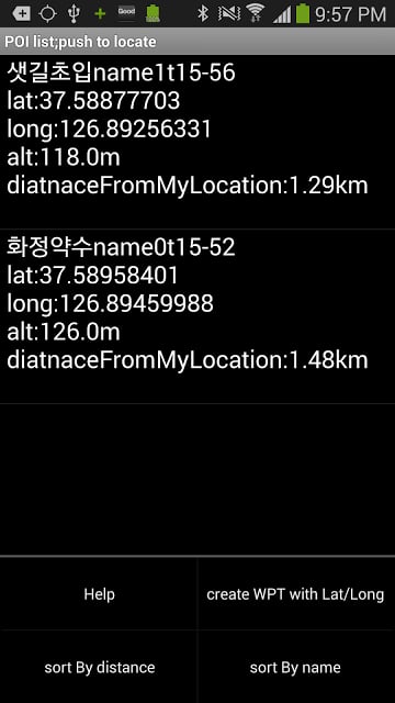
In off line map pane, you can overlay GPX track for you to have idea if you are tracking the target path closely and how far from the target path. Supporting Mapnik/Mapquest maps through Mobile Atlas Creator(which is available in the host PC). Marked POIs in the navigation pane are being drawn as logging POIs. Can navigate quickly to track, where am I, and POIs with buttons in the screens. Target track/POIs are being shown in red color and logging tracks (my position trails)/POIs are shown in black color. Split screen shows altitude target (yellow) , and current altitude(white), which can be dynamically enabled/disabled with screen button(mountain figure).
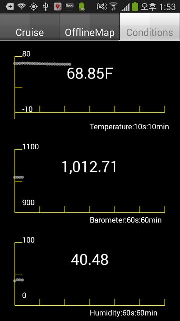
Temp/baro/humidity sensors reading and trends(in case that your device has these sensors).
Freely navigating between navigation and offline map panes.
Catch me/follow up function:If the app receives SMS message with valid latitude and longitude with, then the app parse the SMS message and file it as logging point.
Suppose that two groups are in trekking, then the first group might want to inform the location periodically to the latter group. Then the first group send a SMS to the latter group for them to chase with time stamp and short message.
Valid message examples and rule:
lat37.5793889 long126.884542 (there should be space between lat and long and no space between lat/long and corresponding numbers)
atitude37.5793889 longitude126.884542 (full name of latitude and longitude are being recognized)
provider:gps latitude37.5793889 longitude126.8845 (the logging POI shown with "G". if you don't specify provider, it shown with "U")
provider:network latitude37.5793889 longitude126.8845 (the logging POI shown with "N".)
we will wait here provider:gps latitude37.5793889 longitude126.8845 (message to be shown in the map)
catch me latitude37.5793889 longitude126.884542 (message should come earlier than "provider" or "lat/long")
There is an android app("One shot sms") which can automatically encapsulate the location info with message body as a reference. You just put message body and
send it with wLocation, then the message is automatically encapsulated with provider/and lat/long/accuracy of the position.
No Ads version is also available.
理想用于长途跋涉,徒步,远足,登山,骑自行车,骑自行车和离线地图循环。
使用GPS,它可以显示当前的速度和行驶距离。叠加在地图上的当前位置和目标轨道。
GPX出口绘制路径在谷歌地球或内置在地图中查看。 http://utrack.crempa.net/是分析你的音轨与高度和速度的好节目。为此,您需要确保出口记录为“追踪”按钮,当您因为该网站导出GPX不接受航点为基础的GPX档案轨迹。 http://www.routeconverter.de/home/en也是一个相当不错的程序太具有处理每一个GPX文件的综合能力。
在导航窗格中,您可以看到当前位置和行驶距离。您可以更改字体大小动态fiting在目标设备的最佳视图。背景/前景地面颜色是可以改变的与光线感应器自动调整。或者你可以解决它。
离线地图窗格中,而不需要互联网连接。
在离线地图窗格中,可以覆盖GPX轨迹对你有主意,如果你密切跟踪目标路径,以及如何远离目标路径。支持Mapnik / Mapquest服务映射通过手机阿特拉斯创造者(这是可以在PC主机上)。在导航窗格中标注的POI正在绘制记录的POI。可以快速定位跟踪,我在哪里,和兴趣点在屏幕的按钮。目标跟踪/兴趣点被显示为红色和记录轨迹(我的位置路径)/兴趣点显示为黑色的颜色。分屏显示低空目标(黄色),和目前的高度(白色),它可以动态地启用/禁用屏幕按钮(山图)。
温度/气压/湿度传感器读数和趋势(如果您的设备有这些传感器)。
导航和离线地图窗格之间自由地航行。
追我/跟踪功能:如果应用程序接收到有效的经度和纬度与SMS消息,然后应用程序解析SMS消息并把它作为记录点。
假设两个组都在徒步旅行,那么第一组可能要定期向位置到后者。然后,第一组发送短信到后一组为他们追逐与时间戳和短消息。
有效的消息实例和规则:
lat37.5793889 long126.884542(应该有lat和长和纬度/经度和相应的数字之间没有空格之间的空间)
atitude37.5793889 longitude126.884542(经度和纬度的全名是被认可)
供应商:GPS latitude37.5793889 longitude126.8845(带“G”所示的日志记录的POI,如果你不指定提供商,它以“U”表示。)
提供商:网络latitude37.5793889 longitude126.8845(用“N”表示记录POI)。
我们将在这里等待供应商:GPS latitude37.5793889 longitude126.8845(在地图上显示消息)
抓住我latitude37.5793889 longitude126.884542(消息应该早于“供应商”或“纬度/经度”)
有一个Android应用程序(“一杆短信”),它可以自动封装与邮件正文中的位置信息作为参考。你只要把邮件正文和
它与wLocation发送,则该邮件会自动封装与供应商/和位置的纬度/经度/精度。
无广告版本也已经推出。
trekking biking hiking更新内容
*starting time stamp added with Ttotal. Refreshed when reset button pushed. Good to know when the trip has been started


网友评论更多