CitySurf Globe is a 3D Virtual globe system. This is mobile version of Windows Desktop Application.
Through OpenGL APIs, CitySurf Globe presents high performance navigation solutions by using hardware acceleration features of devices.
If you want to serve your own raster images or detailed vector based data such as roads, buildings, parcel, poi...etc. you can use Citysurf Globe Server (contact with us).
Try :
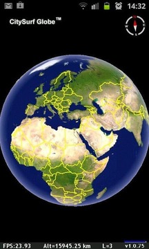
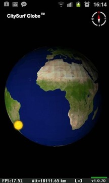
- Use Full Globe Navigation. (with 2 finger pinch zoom)
- Tilt and rotate screen by on screen Scroll bars.
- Rotate globe dynamically to north by Digital Compass (Enabled by Pressing Compass icon)
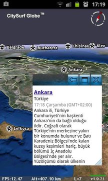
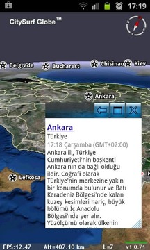
- View feature attribute information
- Display Server side GIS Map Services (wms,wmts,tms,wms-c, digitalglobe xyz)
- Use your GPS and follows your GPS location
- Search and fly to location
- Find Directions between A,B points by using different Providers like MapQuest,OpenStreetmap or CityServer
- Measure Line/Path distance
- Display Sun Position by GMT Time of your device.
- Add new objects to My Places Tree.
- Add Placemark+Photo and send to Community.
Features :
- Supports All size of Android Devices.(Phone and Tablets)
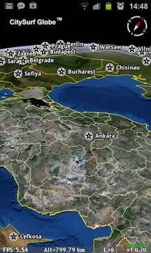
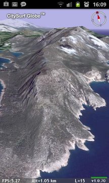
- Display of aeriel and and satellite images
- Working with SRTM, Aster gdem or high resolution local DTM data (geotiff,hgt, dem etc..)
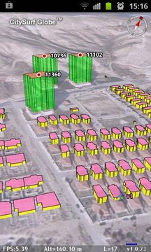
- Vector Object Drawing as Layers. (Points / Lines / Closed Areas / Buildings / Roads etc.)
- 3D Models.(WaveFront Object *.obj)
- Supports Unlimited Size of Data. (Means your server can serve ALL of the world)
- Client side data caching.
- Data collection, editing and sharing
* Intelligent form-based data entry can be designed by Globe Server due to the organization needs
* Attachment of photos, movies, voices to the collected data
* Use of GPS coordinates
- Supports Oracle SDO, Postgres, Esri SHP, MapInfo TAB,MIF
- My Places ( You can draw your own Objects such as points, lines, closed areas...)
They dont deleted when you uninstall application. ( /Phone/CitySurf/myplaces.dml file)
You can copy your myplaces.dml file from Windows Desktop Version of Citysurf to here with same name...
Citysurf Globe PRO version :
These further features are going to be included in the incoming Citysurf Globe PRO version
Access your own GIS Map Services (wms,wmts,tms,wms-c, digitalglobe xyz)
Google Earth KML/KMZ import/export
Path Profile / Visibility Analyze Operations
Requirements :
- OpenGL 3D Acceleration. (Real Hardware GPU)
- 64MB Java VM for best performance.
Contact Address:
http://www.citysurf.com.tr
Keywords,Tags :
GIS, 3D Globe, 3D Earth, Map, Mapping, GPS, Navigation, Satellite , Location, Raster, Vector Layer, OGC, WMS, WMS-C, WMTS, WFS, TMS, OpenGL, Client/Server, Sun, GMT, Compass, Oracle, PostGIS, Esri SHP, MapInfo TAB,MIF, 3D, ArcGIS, ArcMap, MapInfo, OpenStreetMap, Google Earth, Terrain, Image Server, Digital Globe, Spatial, City Guide, Harita, Sanal Küre,.
CitySurf地球是一个3D虚拟地球仪系统。这是Windows桌面应用程序的移动版本。
通过OpenGL的API,CitySurf地球使用设备的硬件加速功能提出了高性能的导航解决方案。
如果你想为自己的光栅图像或详细的基于矢量数据,如道路,建筑物,包裹,芋泥...等。您可以使用Citysurf全球服务器(与我们联络)。
尝试:
- 充分利用全球导航。 (带2个手指捏缩放)
- 倾斜并通过屏幕上的滚动条旋转屏幕。
- 旋转地球仪动态向北通过数字罗盘(通过按罗盘图标启用)
- 视图功能属性信息
- 显示服务器端的GIS地图服务(WMS,WMTS,TMS,WMS-C,DigitalGlobe公司的xyz)
- 使用您的GPS,并遵循您的GPS位置
- 搜索和飞至位置
- 查找路线A,B两点之间使用不同的供应商,如Mapquest服务,OpenStreetMap的或CityServer
- 测量线路/路径距离
- 显示Sun的位置由你的设备的格林尼治标准时间。
- 添加新的对象,以我的位置树。
- 新增地标+图片并发送至社区。
产品特点:
- 支持Android设备的所有尺寸(手机和平板电脑)
- 显示aeriel和和卫星图像
- (。的GeoTIFF,HGT,数字高程模型等)与SRTM,ASTER GDEM或高分辨率当地的DTM数据工作
- 矢量对象绘制的图层。 (点/线/禁区/建筑/道路等)
- 3D模型(Wavefront对象* OBJ)
- 支持数据的大小不受限制。 (意味着你的服务器可以为所有世界)
- 客户端的数据缓存。
- 数据收集,编辑和共享
*智能基于表单的数据输入可以通过全球服务器被设计由于该组织的需求
*的照片,电影,声音附件将采集到的数据
*使用GPS坐标
- 支持Oracle SDO,Postgres的,ESRI SHP,MapInfo的TAB,MIF
- 我的位置(你可以自己绘制的对象,如点,线,封闭区域......)
他们不删除的,当你卸载应用程序。 (/电话/ CitySurf / myplaces.dml文件)
您可以从Citysurf的Windows桌面版本复制您的myplaces.dml文件,这里用相同的名称...
Citysurf地球PRO版本:
这些进一步的特征将要包括在呼入Citysurf地球专业版
访问您自己的GIS地图服务(WMS,WMTS,TMS,WMS-C,DigitalGlobe公司的xyz)
谷歌Earth的KML / KMZ导入/导出
路径资料/可视性分析操作
要求:
- OpenGL的3D加速。 (真正的硬件GPU)
- 64MB的Java虚拟机以获得最佳性能。
联系方式地址:
http://www.citysurf.com.tr
关键字,标签:
地理信息系统,三维地球仪,3D地球,地图,测绘,GPS,导航,卫星,位置,光栅,矢量层,OGC,WMS,WMS-C,WMTS,WFS,TMS,OpenGL中,客户机/服务器,太阳,GMT,指南针,甲骨文,PostGIS的,ESRI SHP,MapInfo的TAB,MIF,3D,ArcGIS中,ArcMap中,MapInfo的,OpenStreetMap的,谷歌地球,地形,图像服务器,数字地球,空间,城市指南,Harita,萨纳尔吴。
CitySurf Globe更新内容
v1.0.92
- Android 4.2 bugs fixed
v1.0.91
- You tube video play support
v1.0.90
- Road Names are drawing 3D Over Road.
- Supports server side 3D Textured Models download and display.


网友评论更多