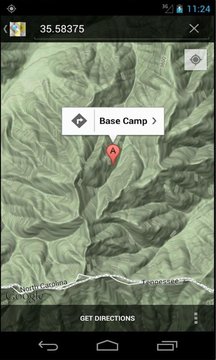
Waypoint is a waypoint manager that allows you to save and manage waypoints. Waypoints can be plotted on a map to access information about the waypoint or viewed in Google Maps to access directions, streetviews, or topographical map data if available.
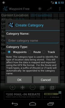
Waypoint allows you to easily organize your location data by creating categories which specify the type of location data being stored. Three types of location data are supported, Waypoints, Routes, and Tracks. The type of location data choosen for each category will determine how the data is mapped and exported using the export to GPX feature.
Categories can be used to store your favorite fishing, boating, hunting, parking, or any other kind of location data you can think of.
Categories and Waypoints are all fully manageable: Create, Rename, Move waypoints between categories, and Delete.
Waypoint can also notify you when you are within a certain distance of your waypoint by enabling the Proximity Alert feature. With the proximity alert enabled you will receive a system notification indicating your are within the set proximity of your waypoint. This feature can be set in the Edit Notifications menu item.
Want to share your location with other friends or send your friends your Waypoints? Use the Share Location and Share Waypoint feature to easily email, SMS, Facebook, Twitter, etc. your locations to your friends. This feature is only available in Waypoint Pro.
*** Free Version is ad supported and allows 3 waypoints. Not all feature are available in the free version. If you would like access to all features, install the paid version Waypoint Pro ***
Features:
- Car Locator
- Fishing Locator
- Hunting Locator
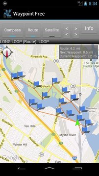
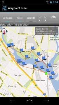
- Map View
- Google Maps Directions/Integration
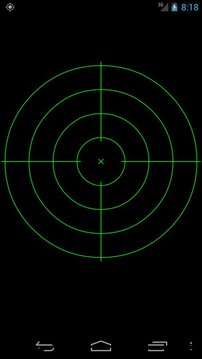
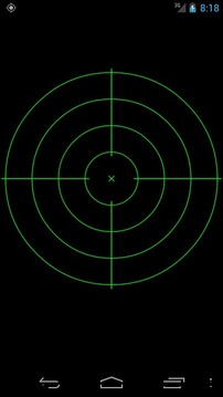
- Radar View
- Category Support and Management
- Waypoint Management
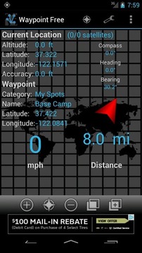
- Compass
- Speedometer (mph, km/h, and knots)
- Proximity Alert
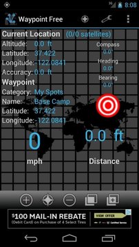
- Bearing between two locations
- Distance between two locations (feet, miles, meters, kilometers, and nautical miles)
- Coordinate Converter
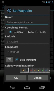
- Latitude/Longitude (Degrees, Minutes, and Seconds format)
- Manually enter coordinates (Degrees, Minutes, and Seconds format)
- Set coordinates from map
- Displays total Route/Track distance
- Displays distance to next waypoint
- Displays distance to the selected waypoint
- Route tracker
- Track tracker
Upgrade to Waypoint Pro for the following additional features:
- No Ads
- Export Waypoints to GPX, KML, or CSV file formats for use in other GPS devices or Google Earth
- Share your current location via email, SMS, Facebook, Twitter, etc.
- Share your Waypoints via email, SMS, Facebook, Twitter, etc.
- Unlimited waypoints
- Landscape mode on main screen
- Import location data from GPX files
- Import location data from KML files
- Import location data from CSV files
- Backup Waypoint data
Accuracy depends on your GPS signal and your device. When locating a waypoint take the Accuracy of your current location into consideration.
Email dev with any issues before posting negative ratings.
航点航点管理器,允许您保存和管理航点。可以在地图上绘制航点访问信息的航点,或查看谷歌地图来中访问的方向,streetviews,或地形图数据,如果有。
航点可让您轻松地组织您的位置数据,通过创建指定类型的位置数据被存储类别。支持三种类型的位置数据,航点,航线和轨道。位置数据的类型选择自每个类别将决定如何将数据映射和出口的使用出口到GPX功能的。
分类可用于存储您最喜爱的钓鱼,划船,狩猎,停车场,或任何其他类型的位置数据,你能想到的。
分类和航点是全面管理:创建,重命名,移动类别之间的航点,并删除。
航点也可以通知你当你是在一定距离内接近警报功能使您的航点。接近警报启用后,您会收到系统通知,说明您是在您的航点附近的。在“编辑”通知“菜单项,可以设置此功能。
要与其他朋友分享您的位置,或发送给您的朋友,您的航点?使用共享位置和分享的航点功能可以轻松地通过电子邮件,短信,Facebook,Twitter的,等你的位置给你的朋友。此功能仅适用于专业航点。
***免费版本的广告支持,允许3航点。并非所有的功能都可用的免费版本。如果你想获得的所有功能,安装付费版本航点,临***
产品特点:
- 车载定位器
- 钓鱼定位
- 狩猎定位
- 地图
- 谷歌地图路线/集成
- 雷达观
- 分类支持和管理
- 航点管理
- 指南针
- 车速表(英里,千米/小时,和节)
- 接近警报
- 在两个位置之间的轴承
- 两个位置(英尺,英里,米,公里,海里的距离)
- 坐标转换
- 纬度/经度(度,分,秒)
- 手动输入坐标(度,分和秒格式)
- 设置从地图中的坐标
- 显示总的路线/曲目距离
- 显示到下一个航点的距离
- 显示距离选定的航点
- 路由跟踪
- 轨道跟踪
升级到航点Pro的以下附加功能:
- 没有广告
- GPX,KML,CSV文件格式导出航点在其他GPS设备或谷歌地球
- 分享您的当前位置通过电子邮件,短信,脸谱,Twitter的,等等。
- 分享您的航点,通过电子邮件,短信,Facebook,Twitter的,等等。
- 无限航点
- 主屏幕上的景观模式
- 从GPX文件的导入位置数据
- 导入KML文件的位置数据
- 位置数据导入CSV文件
- 备份的航点数据
精度取决于GPS信号和设备。查找航点时,您的当前位置精度的考虑。
邮件开发的任何问题,然后再发布负面的评价。
航点免费更新内容
Waypoint Free 6.2 has been released.
- The Radar function has now been restored.
The Radar feature always relied on sample application provided by Google. This application was removed from Google Play which caused new install to not be able to find the application. I have now released the Open Source Radar application under my account.


网友评论更多