Change the way you use GPS for field mapping and scouting applications in agriculture. Trimble’s Connected Farm™ scout app uses your phone's GPS for mapping field boundaries, marking flags, and entering scouting information for points, lines, and polygon areas. Select from an extensive list of weeds, insects and diseases while entering the severity of a problem, crop condition, and more. Photos can also be captured and integrated with your scouting information.
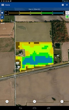
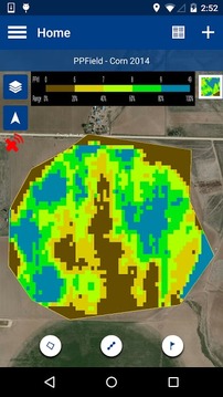
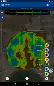
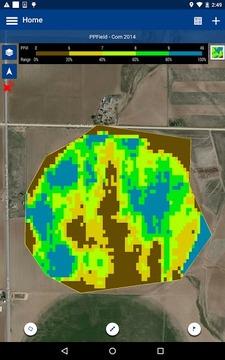
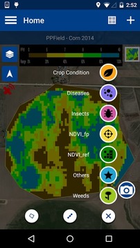
The Connected Farm scout app is compatible with the PurePixel™ precision vegetation health solution. PurePixel allows you to analyze the crop health at various stages of the growing season. These vegetation maps can display in the background to help navigate you to struggling areas of the field, saving you precious time with targeted scouting.
The app is flexible to use with any crop such as corn, wheat, soybeans, cotton, rice, vegetables, and more.
All data is sent via the cell or WI-FI connection to Connected Farm (www.connectedfarm.com) where you can view, sort, and print data online. The app is also compatible with Farm Works Software®.
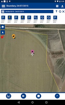
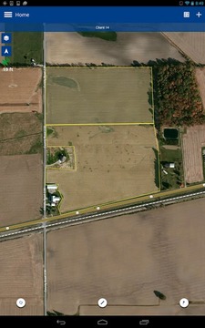
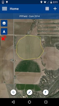
FIELD BOUNDARY MAPPING
• Calculate areas (acres or hectares) and map field boundaries.
• Utilize the offset feature to enter a distance between you and the actual boundary when logging.
• Display background satellite imagery
GENERAL MAPPING
• Switch between logging paths, points, and polygon areas.
• Customize personal notes to various jobs.
• Enter data easily without a keyboard using the built-in pick list.
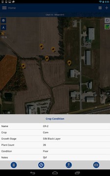
SCOUTING
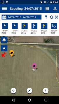
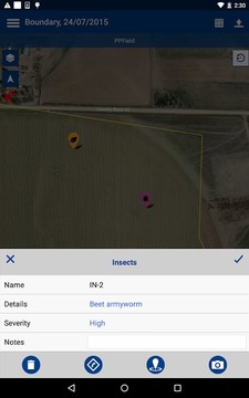
• Enter scouting attributes for pests, weeds or diseases and log the severity of problems and crop conditions.
• Capture and geo-reference digital images of pests using the phone or tablet’s built-in camera and GPS.
• View PurePixel vegetation health imagery in the background to help with targeted scouting.
• View previously logged scouting data in the background to help understand if areas are improving or not.
NITROGEN RECOMMENDATIONS
• Calculate nitrogen rates by using NDVI (Normalized Difference Vegetation Index) crop readings from the GreenSeeker handheld crop sensor.
• Saves the geo-referenced location of the NDVI point.
DATA MANAGEMENT
• Manages your data by client, farm, and field names.
• Transfer your data to the Connected Farm where you can view, sort, and print your data online.
• Utilize your Connected Farm account to automatically backup your data. Never lose data again.
• Compatible with Farm Works Software.
-----
Note: Continued use of GPS running in the background can dramatically decrease battery life.
改变您使用在农业领域的映射和侦察应用GPS的方式。 Trimble的连接农场™侦察应用程序使用手机的GPS映射区域边界,标识标志,并进入了点,线,多边形区域侦察信息。从广泛的杂草,昆虫和同时输入问题的严重性的疾病,作物的条件和更列表中选择。照片也可以被捕获并与侦察的信息集成。
连接的农场侦察应用与PurePixel™精植被的健康解决方案兼容。 PurePixel允许您分析作物健康的生长季节的不同阶段。这些植被图可以在后台显示,以帮助您导航挣扎的领域方面,为您节省宝贵的时间有针对性的侦察。
该应用程序是灵活的与任何作物使用,如玉米,小麦,大豆,棉花,水稻,蔬菜等。
所有的数据通过细胞或WI-FI连接,连接农场(www.connectedfarm.com),您可以查看,排序和打印数据在线派出。该应用程序也与农业工程软件®兼容。
场边界映射
•计算面积(亩或公顷)和地图领域的界限。
•利用偏移功能登录时你和实际边界之间进入的距离。
•显示背景卫星图像
一般映射
•记录路径,点和多边形区域之间切换。
•自定义个人笔记,以各项工作。
•轻松地输入数据,而无需使用内置的选择列表中的键盘。
侦察
•害虫,杂草或疾病进入侦察属性和日志的问题和作物状况的严重程度。
•使用手机或平板电脑害虫的采集和地理参考数字图像内置摄像头和GPS。
•在后台查看PurePixel植被的健康形象,以帮助有针对性的侦察。
•查看以前记录在后台侦察数据,以帮助理解,如果区域改善与否。
氮建议
•使用NDVI(归一化植被指数)作物的读数从GreenSeeker手持作物传感器计算氮率。
•保存NDVI点的地理参考位置。
数据管理
•通过客户端,农场,场名称来管理您的数据。
•您的数据传输到连接的农场在这里你可以查看,排序,并在线打印数据。
•利用您连接农场账户自动备份您的数据。再也不会丢失数据。
•与农场工程软件兼容。
-----
注意:继续使用全球定位系统在后台运行,可以大大减少电池寿命。
Connected Farm Scout更新内容
- More bug fixes
Send feedback to support@connectedfarm.com


网友评论更多