Moon maps galore! Scroll, zoom and search through high resolution US Geological Survey and NASA maps. LunarMap is fun for anybody who wants to see and know more about earth's lovely satellite and is a great companion for amateur astronomy observations through a telescope.
The Lite version watermarks zoom levels above 8X and does not include terminator (shadow line) display and satellite features (e.g., it includes Plato but not Plato B).
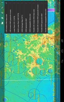
Features of LunarMap include:
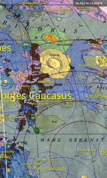
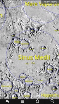
- Nearside and farside of the moon
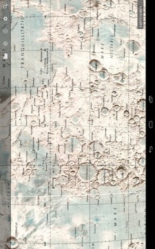
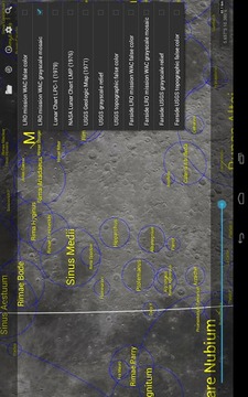
- Realistic US Geological Survey relief map (5120x5120 resolution)
- Beautiful photographic map from the Lunar Reconnaissance Orbiter's Wide Angle Camera (nearside 20480x20480)
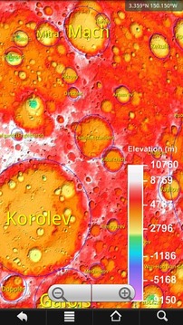
- Color-coded topological maps from both the USGS and NASA
- Realtime terminator (shadow) line
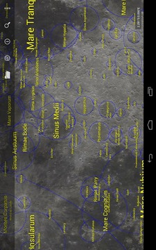
- Searchable labels for over 1900 craters, maria, mountains, valleys, Apollo landing sites and more, based on International Astronomical Union data; tap on feature for more information or to lookup in Wikipedia
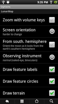
- Rotate and/or flip the map to match your telescope's eyepiece view, or for users in the southern hemisphere
- Zoom with two fingers (multitouch devices only), on-screen buttons or volume keys
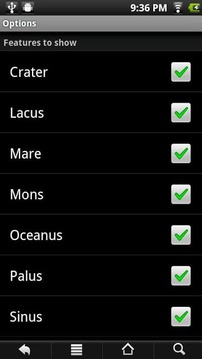
- Customize colors, labels shown and other features
- Optionally lock screen rotation or make it harder to change so you need to turn the device further than usual to rotate to prevent accidental screen rotations while observing
- The maps are 2D. The nearside maps are projected to show a small portion of the farside, since libration can reveal a small portion of the farside
Note: To save app download time, maps other than the USGS relief nearside map involve an additional free in-app download, hence the Internet permission.
月球地图一应俱全!滚动,缩放和搜索高分辨率美国地质调查局和美国航天局的地图。 LunarMap是有趣的人谁愿意看到和更了解地球的可爱的卫星,是通过望远镜业余天文观测一个伟大的同伴。
精简版的版本水印放大8倍以上的水平,不包括终止符(影线)显示器和卫星功能(例如,它包括柏拉图,但不是柏拉图B)。
LunarMap的特点包括:
- 左标和月亮的farside
- 真实的美国地质调查局地形图(5120x5120分辨率)
- 从月球勘测轨道飞行器的广角相机(左边20480x20480)美丽的照片图
- 颜色编码来自美国地质调查局和美国航天局的拓扑图
- 实时终止(影子)线
- 超过1900环形山,月海,高山,峡谷,阿波罗着陆点多,根据国际天文学联合会的数据检索的标签;点选功能的更多信息,或者在维基百科上查找
- 旋转和/或翻转地图,以符合您的望远镜的目镜看,或为用户在南半球
- 放大用两个手指(仅多点触控设备),屏幕上的按钮或音量键
- 自定义颜色,显示标签和其他功能
- 可选锁定屏幕旋转或使其难以改变,所以你需要打开设备比平时进一步转动,以防止意外的屏幕旋转,同时观察
- 该地图是2D。近侧地图被投影到显示farside的一小部分,因为平动可以揭示farside的一小部分
注:为了节省应用程序的下载时间,地图比美国地质调查局救灾左边地图其他涉及额外免费的应用程序下载,因此Internet权限。
LunarMap Lite更新内容
1.41: More optimization
1.40: Optimization; new map format; giant farside WAC map
1.34: Giant 20480x20480 nearside WAC map
1.30: Actionbar
1.21: Restore some missing labels
1.20: Lite version now watermarks the map at zoom levels above 8X (the previous version pixelated at that point) but now includes all the maps from the HD version!
1.14: Minor optimization and bug fixes
1.12: Add option to remove zoom buttons
1.11: Add astronaut named features
1.10: Add over 7000 satellite features


网友评论更多