Multimedia-Tour guide with Topo maps for the european alpine region. GPS-Tracks for Android is designed for the application at hiking, theme trails, GEO-caching, cycling, snow trail tours, ski tours, MTB, site seeing tours, etc.
Runs on:
All Android-Phones from version 2.1.
Attention:
If the App is moved to the background, the GPS-receiving continues. This can quickly discharge the battery.
Features:
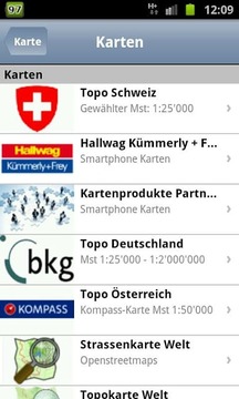
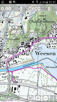
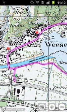
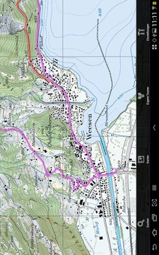
- Original, free Topo maps from scale 1:25'000 for Switzerland, Germany and Austria. Openstreetmaps and Opencyclemaps for worldwide use.
- Complete footpath, cycling and further networks to overlay the maps. Examples: footpath network Switzerland, cycling network Switzerland and South Germany, ....
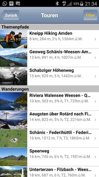
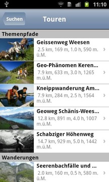
- «Top of»-routes: Integrated Tour-guide with over 7500 professional created routes in the field of hiking, theme trails, cycling, mountainbike, ski tours, snow trail tours, transalp, etc. Following the principle: just the best routes of the region!
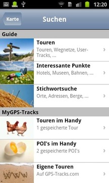
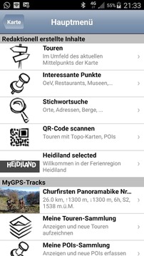
- Over 250'000 Points of interests, like hotels, museums, sights, ... – provided by our tourism-partners.
- Routing via leisure-path networks e.g. from point A to point B via footpaht network.
- Free text search in all databases. E.g. for mountain names, locations, addresses, etc. Alignment oft he map on these points.
- Recording of your own routes and waypoints and saving them on the phone or on www.GPS-Tracks.com.
- Revolutionary: With a free account on www.GPS-Tracks.com you can plan your routes (using the whole assortment of Topo- and satellite maps) and transfer them to the phone without any installation of software or maps. You do not need to connect the phone to the computer. Plan routes unlimitedly and recall them anytime and anywhere.
- All routes, POI's and maps can be saved on the phone (in case there is no telephone connection on the way).
- Simple user guidance: without initial effort or previous knowledge easily operated.
Important:
- All data can be saved on the phone. You can e.g. transfer data at home on a WiFi network to your phone and hence will be independent of a data connection on the way. If additional data is loaded through the internet connection on the way, we recommend to open a data subscription at your telecommunications provider. 30 MB per month are enough for that purpose. For a route Tour incl. all map data approx. 3 MB are loaded.
This App and its content were developed with the support from i.a.:
- Adelboden / Frutigen Tourismus
- Allgäu Tourismus
- Brigels Tourismus
- Colltex Skihaftfelle
- Chur Tourismus
- Davos Klosters Tourismus
- Swiss Cyling - Schweizerischer Radfahrerbund
- Engadin- St.Moritz Tourismus
- Entlebuch Unesco Biospärenreservat
- Fribourg Tourismus
- Heidiland Tourismus
- Jungfrau-Tourismus
- Vierwaldstättersee / Lakeluzern.ch Tourismus
- Lenzerheide Tourismus
- Liechtenstein Tourismus
- Luzern Tourismus
- Schweizerischer Alpen-Club SAC
- Schaffhauserland Tourismus
- St.Gallen Business Location
- Meiringen-Hasliberg
- Regiun Surselva
- Ticino Tourismus
- Viamala Tourismus
- Region Willisau
- Stadt Winterthur
- Zürichsee Tourismus
- Zug Tourismus
- Bad Zurzach
多媒体导游与地形地图欧洲高寒地区。 GPS-曲目为Android是专为在远足,主题小径,GEO-缓存,骑自行车,雪道上旅游,滑雪旅游,山地自行车,场地看到游等应用
运行:
所有的Android手机从2.1版本。
注意:
如果该应用程序被移动到背景中,GPS接收继续。这可以快速放电的电池。
产品特点:
- 原来,从规模1免费地形图:25'000瑞士,德国和奥地利。 Openstreetmaps和Opencyclemaps在世界范围内使用。
- 完整的小径,骑自行车和进一步的网络叠加的地图。例如:小径网络瑞士,骑自行车网络瑞士和德国南部,...
- «返回»-routes:集成导游有超过7500的专业创建于登山,主题小径,骑自行车,山地自行车,滑雪旅游,冰雪旅游步道,transalp等领域继方针路线:刚刚最佳路线该地区的!
- 超过250,000点的利益,如酒店,博物馆,旅游景点,... - 只要我们的旅游合作伙伴。
- 通过休闲路径网络例如路由从A点到通过footpaht网络B点。
- 在所有数据库全文检索。例如山地名称,位置,地址等经常对准他映射在这些问题上。
- 你自己的航线和航点的记录,并将其保存在手机或www.GPS-Tracks.com。
- 革命:随着www.GPS-Tracks.com你可以计划你的路线(使用Topo-和卫星地图的全品种)和他们没有任何安装软件或地图传送到手机上免费的账号。你不需要将手机连接到电脑。规划路线,并无限随时随地调用。
- 所有路线,POI的和地图可以保存在手机上(万一有路上没有电话连接)。
- 简单的用户指导:没有初始的努力或以前的知识很容易操作。
重要事项:
- 所有的数据可以保存在手机上。您可以如在家里的WiFi网络上的数据传输到您的手机,因此将独立的道路上一个数据连接。如果更多的数据是通过在路上的互联网连接加载,我们建议您在电信运营商打开一个数据订阅。 30 MB,每月有足够的用于这一目的。对于路线游含所有的地图数据约。 3 MB加载。
这个应用程序及其内容进行开发与IA的支持:
- 阿达尔波登/弗鲁蒂根旅游局
- 阿尔旅游局
- 布里格尔斯旅游局
- Colltex Skihaftfelle
- 库尔旅游局
- 达沃斯克洛斯特斯旅游局
- 瑞士Cyling - Schweizerischer Radfahrerbund
- Engadin-圣莫里茨旅游局
- 恩特勒布赫联合国教科文组织Biospärenreservat
- 弗里堡旅游局
- Heidiland旅游局
- 少女峰 - 旅游局
- Vierwaldstättersee大街/ Lakeluzern.ch旅游局
- 伦策海德旅游局
- 列支敦士登旅游局
- 卢塞恩旅游局
- Schweizerischer阿尔卑斯山俱乐部SAC
- Schaffhauserland旅游局
- 圣加仑业务地点
- 迈林根 - 哈斯利伯格
- Regiun的Surselva
- 提契诺州旅游局
- Viamala酒店旅游局
- 地区维利绍
- 施塔特丰泰
- Zürichsee旅游局
- 楚格旅游局
- 楚尔察赫
GPS轨道定位更新内容
1) New additional layer with all Swiss hiking trails:
Yellow: Trail
Red: Mountain Trail
Blue: Alpine hiking trail
Violet: ferrata
Green: All national and regional routes SwitzerlandMobility.
Light green: summer lifts
2) New additional layer with all Swiss cycling routes cycling in Switzerland. The color corresponds to the slope of the path:
Green: 0 - 3.5%
Yellow: 3.5 - 7%
Red: 7 - 10.5%
Dark: 10.5 - 14%.
3) Germany-Topo maps can be reupholstered without registration for offline use.


网友评论更多