SityTrail is a GPS for all of your outdoor activities anywhere in France.
Here are its main functions:
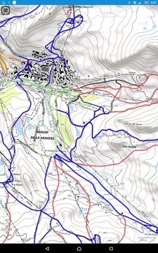
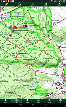
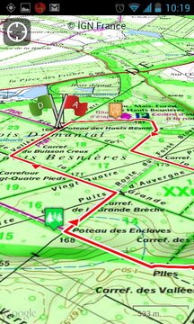
★ IGN FRANCE TOPOGRAPHIC MAPS IN YOUR POCKET
All the topographic maps you need to discover France, Corsica and Overseas departments and territories on foot, cycling, horse riding, or by car, motorbike or quad.
Subscription charge: The application can be accessed for free for a week’s trial. You may then take out a subscription for €24.99 per year or €11.99 per month, all-inclusive.
Tourism and discovery
Discover the new 1:25 000 IGN map ideal to (re)discover an area on foot, bicycle, horseback or car. The series includes coverage of mainland France, Corsica and Overseas departments and territories representing all relevant information for outdoor activities: roads, trails, streams, tourist sites, shelters, rest houses, buildings, religious buildings, ...
The Grandes Randonnées
The GR ®, maintained by the French Federation of Ramblers, are also displayed: 60,000 km of hiking trails! Also shown on the maps are the PR ® (petites randonnées) shorter walks for a day.
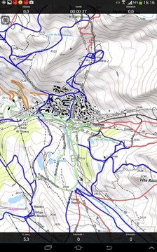
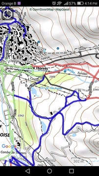
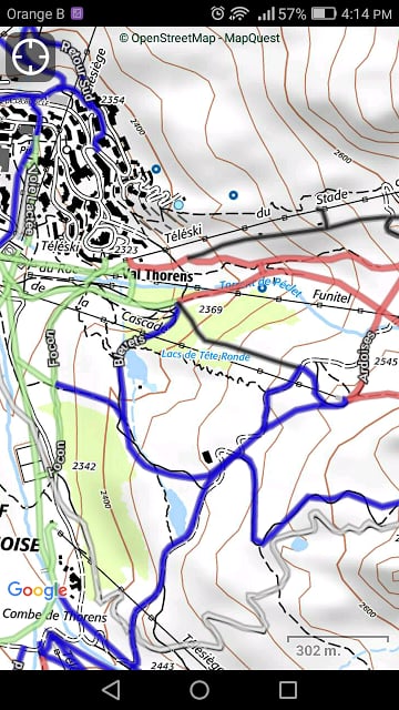
★ MAPS AND YOUR WALKS AVAILABLE IN OFFLINE MODE
The download tool lets you get the most out of your maps and routes on the ground without any internet connection.
There is an alarm when you stray from the route being followed. No more need to continuously check your smartphone, this alarm system will stop you getting lost or having to turn back on yourself.
Automatic activation of points of interest and text to speech synthesis.
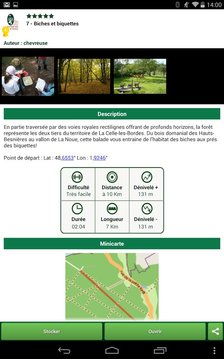
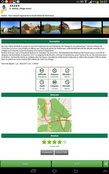
An elevation profile that enables the visualisation of inclines and of any difficulties along the route.
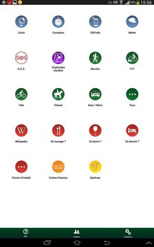
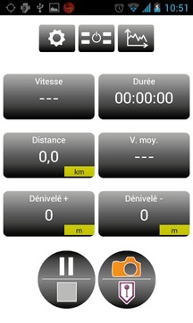
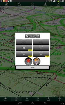
★ RECORD YOUR ROUTES WITH PHOTOS
Record your walks in real time on the ground, and create points of interest with your own photos and commentary.
Display showing distance covered, time taken, average speed, GPS altitude, inclines (+/-), and many other useful indicators for walkers and mountain bikers.
Estimate of distance and time remaining based on your average speed.
Elevation profile for the current recording.
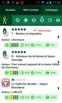
★ CREATE AND SHARE YOUR WALKS
With our online editor, create your own walking projects using an internet navigator on your PC/MAC and then accessing them directly from your mobile to experience them on the ground.
Go further. Transform your favourite walks into real multimedia guides with text, photos, video links, and share them with the SityTrail community.
Access too to thousands of walking circuits from other members and let yourself be guided!
★ TOURIST ATTRACTIONS AND WEATHER SERVICE
Get plenty of localised tourist information: articles Wikipédia, accommodation, restaurants, and various services such as chemists and banks.
Save your favourite places so you can consult them during your trip.
Check on the five-day weather forecast for any location on the map to help you organise your stay.
★ ADDITIONAL FUNCTIONS
Easily create points of interest, such as the location of your car, your hotel, or a restaurant.
In the event of any problems, the SOS function enables you to send your GPS coordinates to your contacts.
Geocachers can use the compass to find their way to a geocache.
★ ANDROID WEAR SMARTWATCH
- Route and GPS position visualisation.
- Indication of distance covered and remaining.
- Arrow display indicating the direction to be taken.
- Alarm when you stray from the route.
We wish you lots of fun with SityTrail France.
Application Manual: http://www.sitytrail.com/lang-en/manuals_trail.html
For any questions or suggestions: http://www.sitytrail.com/lang-en/support_trail.html
- - -
Some functions need an internet connection.
The prolonged use of GPS can reduce battery levels.
SityTrail是您所有户外活动的任何地方在法国GPS。
下面是它的主要功能:
★ IGN法国地形图,在你的口袋
所有地形图,你需要发现步行,骑自行车,骑马,或乘汽车,摩托车或四法国科西嘉岛和海外省和海外领地。
订阅费:应用程序可以免费访问一个星期的审判。然后,您可以拿出认购€24.99每年或€11.99元不等,包罗万象。
旅游和发现
探索新的1:25 000 IGN地图理想的(再)上发现步行,骑自行车,骑马或汽车的区域。该系列包括法国大陆,科西嘉岛和海外省和海外领地代表的户外活动所有相关信息的覆盖范围:道路,小径,溪流,旅游景点,凉亭,休息的房子,建筑,宗教建筑,...
的GRANDESRandonnées
在GR®,由法国联合会漫步者的维护,也显示:远足径6万公里的!同时显示在地图上是PR®(PETITESrandonnées)短散步一天。
★地图和您的漫游路线在离线模式
下载工具可以让你得到最出你的地图和地面路线没有任何Internet连接。
有被人跟踪,当你从路线偏离报警。没有更多需要不断检查您的智能手机,该报警系统会阻止你迷路或有回头自己。
的兴趣和文本到语音合成的点自动激活。
海拔轮廓,使可视化和沿途的任何困难倾斜。
★记录你的航线上照片
记录在地面上实时的散步,并用自己的照片和评论创建的兴趣点。
显示内容覆盖距离,所用的时间,平均车速,GPS海拔高度,倾斜(+/-),并为步行者和骑山地自行车等诸多有用的指标。
距离和时间的估计剩余根据您的平均速度。
当前记录海拔轮廓。
★创建和分享您的散步
与我们的在线编辑器,创建使用PC / MAC上的因特网浏览器,然后直接从您的手机访问他们体验他们在地面上自己行走的项目。
走得更远。将您的最爱走进真正的多媒体与文字,照片,视频链接指导,并与SityTrail社区分享它们。
太给成千上万的行走线路的其他成员和访问让自己的指导!
★旅游景点和气象服务
获取大量的本地化旅游信息:维基百科的文章,住宿,餐厅和各种服务,如化学家和银行。
保存您最喜爱的地方,这样你可以在旅途中征询他们的意见。
检查在地图上的任何位置五天的天气预报,以帮助您安排住宿。
★附加功能
轻松创建的兴趣点,如你的车的位置,你的酒店或餐厅。
如果遇到任何问题的情况下,SOS功能,使您可以发送您的GPS坐标到您的联系人。
Geocachers可以使用指南针找到自己的一个藏宝的方法。
★的Android Wear的SmartWatch
- 路线和GPS位置的可视化。
- 距离指示覆盖,剩余。
- 将要采取指示的方向箭头显示。
- 当你从路线偏离报警。
我们希望你很多的乐趣与SityTrail法国
应用手册:http://www.sitytrail.com/lang-en/manuals_trail.html
如有任何问题或建议:http://www.sitytrail.com/lang-en/support_trail.html
- - -
有些功能需要一个互联网连接。
长时间使用GPS可以减少电池的水平。
SityTrail France更新内容
- Maps downloads are now unlimited (cache "All France") *
- You can now download maps areas with a larger radius (up to 100 km) and download maps and cadastral parcels up to a much more precise zoom level for an offline use
- QRCodes of paid SityTour trails are now taken into account
- Several bug fixes and improvements
* Unlimited cache for downloaded maps (only limited by the remaining space on your device - download speed and performance may vary).


网友评论更多