GPS Data - essential application for all GPS users.
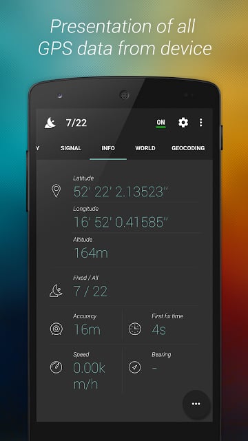
Presentation of all GPS data from device
Position, satellites, gps signal strength
Gps diagnose and gps testing
Splendid user interface: 2 color themes
With GPS Data you can check signal quality, test gps module, check your position/location, satellites count, signal quality, fix time and much more!
The nicest GPS test, status and diagnose app! If your gps navigation works horrible use this app to gps test, diagnose and fix your problem!
Four different tabs are at your service to test and see your GPS data:
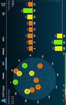
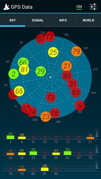
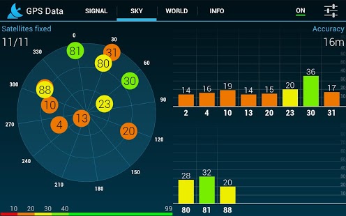
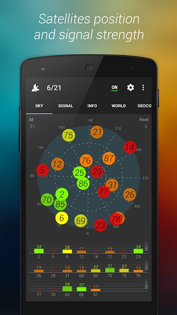
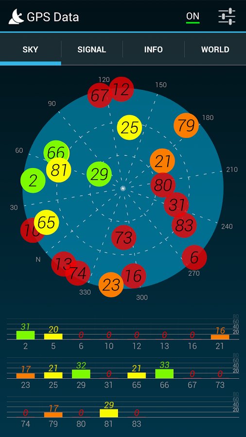
1) Sky tab + signal view – sky map view presents position of satellites connected with device on the sky. Each small circle represents one satellite with color adequate to signal strength and its status. Sky map circle is rotated depending on device compass. Signal strength view presents strength chart of satellites connected with device. Each bar represents one satellite, height of the bar is proportional to received signal strength.
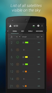
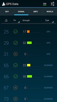
2) Signal tab – list of all satellites connected with device. Each row represents one satellite. With this list you get all details about satellite prn number, info about satellite fix, signal strength and type: GPS/GLONASS. Elevation and altitude is available in landscape mode.
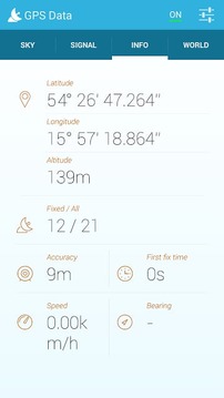
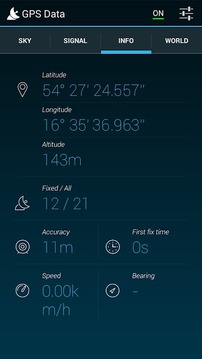
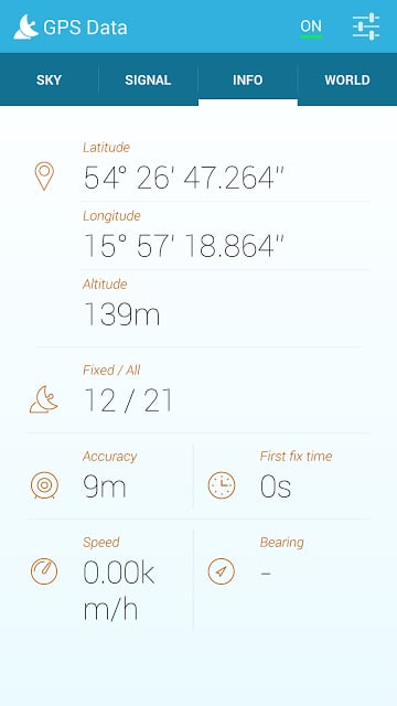
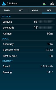
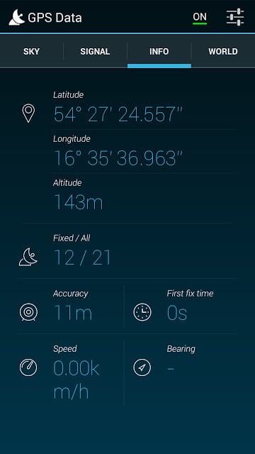
3) Info tab – on this tab all most important data are available, which is:
a.Position info – latitude, longitude, altitude
b.Signal info – accuracy, satellites fixed, first fix time (fft)
c.Movement info – speed, bearing
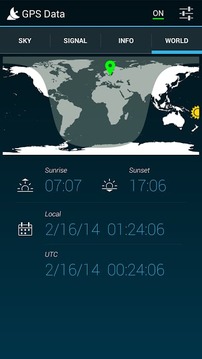
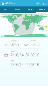
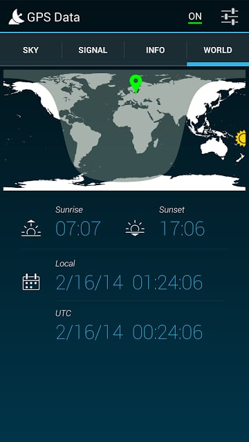
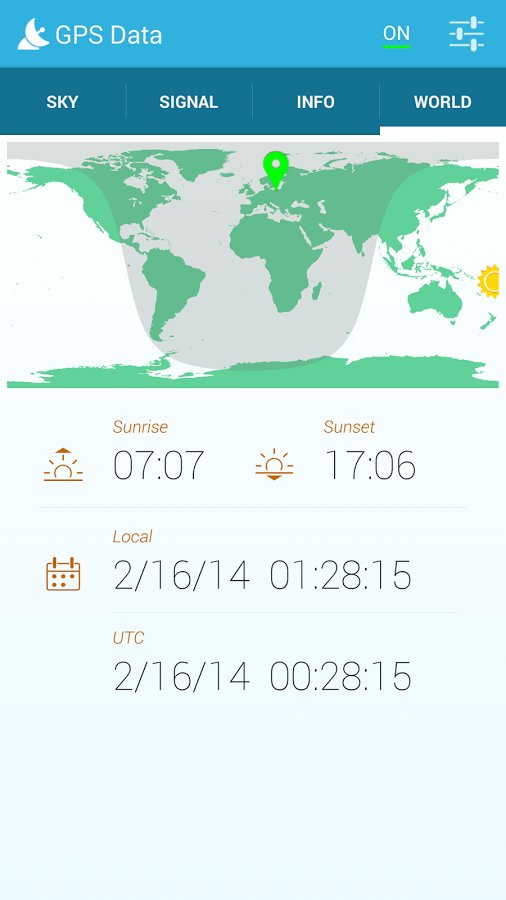
4) World tab – world map view presents position of the device, it also shows global sun position and day-light/night-dark area. There is local and UTC date time from GPS, also time of the sunrise and sunset are available.
5) Geocoding tab - geocode address to world position!
Application offers different measurement units:
a)Position: Seconds, Minutes, Degrees, Universal Transverse Mercador (UTM), Military Grid Reference System (MGRS), Earth-centered, Earth-Fixed (ECEF)
b)Speed: Metric – kmph, Metric – ms, Imperial – mph, Nautical - knots
c)Distance: Metric – meters, Imperial - feet
GPS test and diagnose of your device. Management of A-GPS Xtra Data available:
a) Delete A-GPS Xtra Data
b) Download new A-GPS Xtra Data
Once again:
★ GPS and GLONASS satellite types are available!
★ Satellite sky view
★ Signal strength and signal quality
★ Detailed gps informations
★ Position: latitude, longitude, altitude
★ Gps fix time, accuracy, speed and bearing
★ Sunset, sunrise, day-night map view
★ Two splendid color themes
★ and more....!
GPS数据 - 对所有GPS用户必备的应用程序。
从设备的演示文稿中所有的GPS数据
位置,卫星,GPS信号强度
GPS诊断和GPS测试
锦绣用户接口:2个颜色主题
随着GPS数据,你可以检查信号质量,测试GPS模块,检查你的位置/定位,卫星计数,信号质量,修复时间以及更多!
最好的GPS测试,状态和诊断应用程序!如果你的GPS导航仪的工作原理可怕使用这个程序,GPS测试,诊断和解决您的问题!
四种不同的选项卡为您服务测试,看看你的GPS数据:
1)天卡+信号视图 - 天空地图视图显示与设备上的天空连接卫星的位置。每个小圆圈代表一个卫星的色彩足够的信号强度和状态。根据设备指南针天图圆圈转动。信号强度视图显示与设备相连的卫星实力排行榜。每个条代表一个卫星,所述条的高度正比于接收信号的强度。
2)信号标签 - 与设备连接的所有卫星的名单。每一行代表一个卫星。有了这个名单,你得到有关卫星PRN数,约卫星锁定,信号强度和类型信息的所有详细信息:GPS / GLONASS。海拔高度在横向模式下可用。
3)信息标签 - 这个标签的所有最重要的数据是可用的,这是对:
a.Position信息 - 纬度,经度,海拔高度
b.Signal信息 - 精确,卫星固定,首次定位时间(FFT)
c.Movement信息 - 速度,轴承
4)世界标签 - 世界地图视图显示设备的位置,这也说明全球太阳的位置和日光/夜间暗区。有本地和UTC日期时间从GPS,也日出和日落时间可用。
5)地理编码标签 - 地理编码地址,以世界上的地位!
应用程序提供了不同的计量单位:
a)位置:秒,分,度,通用横轴Mercador(UTM),军事网格参考系统(MGRS),地心,地球固定(ECEF)
B)速度:公制 - KMPH,公制 - MS,皇家 - 英里,航海 - 结
C)距离:公制 - 米,帝国 - 脚
设备的GPS测试和诊断。 A-GPS Xtra的数据可用的管理:
一)删除A-GPS Xtra的数据
B)下载新的A-GPS Xtra的数据
再一次:
★GPS和GLONASS卫星类型可供选择!
★卫星的天空视野
★信号强度和信号质量
★详细的GPS信息
★位置:纬度,经度,海拔高度
★GPS定位的时间,精度,速度和方位
★日落,日出,昼夜地图视图
★两名出色的色彩主题
★多....!
GPS数据管理更新内容
新的光的主题 更好的性能 - Android 4.0支持了


网友评论更多