
ViewRanger的GPS试用


Try out ViewRanger Outdoor GPS for 15 days.
15-day Trial Version Only. Try out ViewRanger Outdoor GPS for 15 days. Ideal for Walking, Hiking, Mountain Biking, Cycling and virtually any Off-Road activity. Want permanent FREE - see our Open version.
Get the most from your 15 days test by registering and get 2 free Premium topographic map tiles*, to use BuddyBeacon, our location sharing service and to store and share trails on the my.viewranger.com community website.ViewRanger lets you plan, plot, navigate, track, locate, record, analyse & share. Works all around the world using topo and road maps or aerial imagery layers that can be stored for offline use.
Buy & download full topographic premium mapping for many countries using in-app purchasing (see ViewRanger store in-app). Any purchase automatically upgrades this version to a permanent licence.
★★★★★ "Innovative software that transforms your phone." Trail Magazine
★★★★★ Sunday Times “must have” app
★★★★★ Featured on Channel 5 Gadget Show
_______________________________________
NATIONAL & GLOBAL OPEN SOURCED MAPS
✔Easily switch map view from street detail to terrain using OpenStreetMap and OpenCycleMap© 2012 OpenStreetMap, CC-BY-SA & contributors
✔Works even without mobile coverage - as these maps can be stored on your phone (off-line), so you get fast, responsive map presentation and can avoid data/roaming charges
✔Also includes Bing Road Maps, Bing Aerial Imagery and others.
✔Use in-app purchasing to buy and install highly detailed topo maps for Canada, USA, European countries & New Zealand.
______________________________________
RECORD YOUR TRIPS
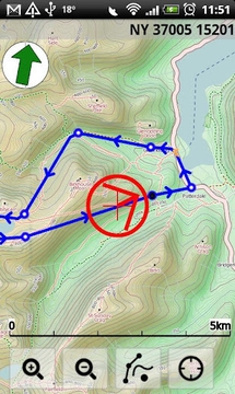
✔Clearly marks your path on the map in real-time.
✔Save the recorded path of your trips, as GPX for export
✔Upload your adventures to My.ViewRanger to share using Facebook or publish to the community
✔Create trip journals with photos from your Flickr™ or Picasa™ accounts
_______________________________________
ALL THE STATS YOU NEED
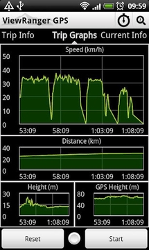
✔Real-time sports computer stats for over 30 metrics (i.e. speed, distance, time, elevation, pace, ETA, etc)
✔Customise screen views in text, dial or graphical format
✔Real-time on-screen map coordinate display (UTM WGS84, NAD27, ITM, Lon/Lat, etc)
✔Supports imperial, nautical and metric units
_______________________________________
EASY TRIP PLANNING USING APP OR WEB
✔Create your own routes with in-app tool or online at My.ViewRanger
✔Import a route as a GPX file
_______________________________________
FULL ON-SCREEN NAVIGATION
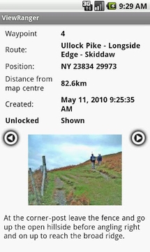
✔Active waypoint navigation with on-screen visual guidance
✔Navigation alarms if you veer too far off track
✔Magnetic compass
______________________________________
LOCATION SHARING*
✔Share your real-time location with BuddyBeacon™
✔See the mapped location of your friends on screen
✔Link your Twitter™ messages, photos & videos
_______________________________________
SEARCH & LOCATE
✔Search by Place name using online services*.
✔Find location using map coordinate entry (ideal for Geocaching)
✔Real-time map coordinate display
✔Mark locations as a Point of Interest (PoI)
Need more info: see our website: www.viewranger.com. Any questions or feedback, please drop us an e-mail: support@viewranger.com
Notes: * registration required, **may incur additional charges ***requires mobile data
此版本中的新功能:
v3.2.3:
* Spanish language added.
* Austrian map support.
* Fixes to a few issues receive by report button.
v3.2:
* New account sign in pages, including option to add a profile name and photo.
ViewRanger的GPS试用


扫一扫安装
豌豆荚发现更多
手机扫码安装豌豆荚


网友评论更多