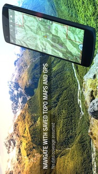
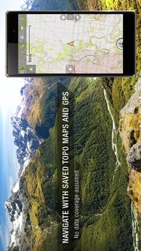
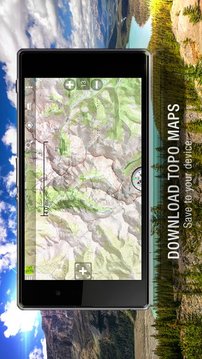
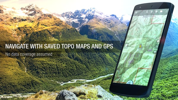
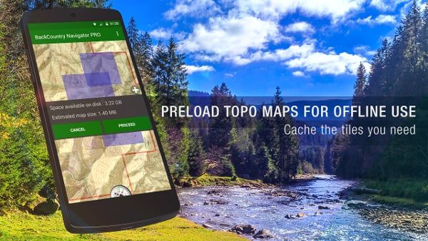
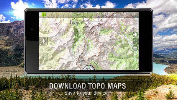
Download topo maps for an offline outdoor navigator! Use your phone or tablet as an offroad topo mapping handheld GPS with the bestselling outdoor navigation app for Android! Explore beyond cell coverage for hiking and other recreation.
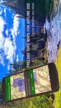
Download topo maps for the US and many other countries in advance, so you won't need cell coverage for navigation. Use storage memory for maps.
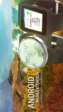
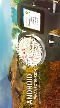
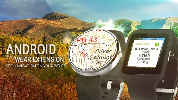
New: Android Wear support to see navigation at a glance on wrist
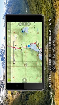
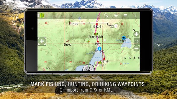
Use GPS waypoints from GPX or KML files, or enter your own coordinates using longitude/latitude, UTM, MGRS, or grid reference. Using GOTO makes a waypoint a locus for navigation.
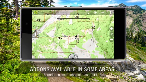
This uses many publicly available map sources as free downloads. Some additional content available as an in app purchase:
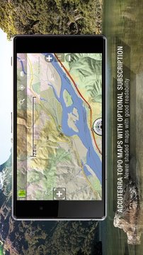
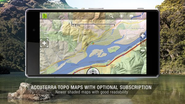
-Accuterra Topo Map Source for $19.99/year. This can be purchased and used with or in instead of the free sources.
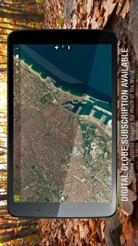
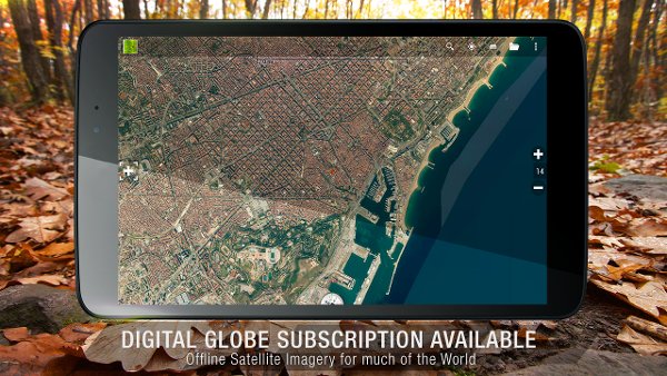
-Digital Globe Subscription allows offline storage of high res satellite imagery for much of the world.
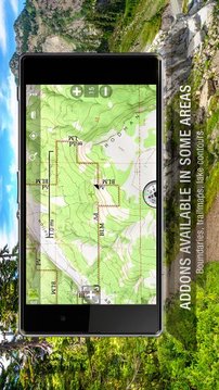
- Boundary maps for 12 western states from the Bureau of Land Management(BLM) Overlay for topo maps valued by hunters.
-GMU boundaries in some states
-Lake Contours in several states.
-Content from US TrailMaps including:
-ATV, Whitewater, and Equestrian Trail Maps
See the menu under More-> "Purchasing AddOns". They can be shown on top of topo maps.
You may try the DEMO version to make sure you like the maps in your country.
About topo (topographic) maps: Topo maps show terrain through color and contours, and are useful for navigation offroad. Topo maps and GPS can be used for hiking, hunting, kayaking, snowshoeing, & backpacker trails.
You can create your own maps with Mobile Atlas Creator, or specify a custom tile server. Built in sources include:
OpenStreetMaps from MapQuest
OpenCycleMaps showing terrain worldwide
US Topo Maps from Caltopo and the USGS
USTopo: Aerial Photography with markup.
Canada Topo Maps from Toporama
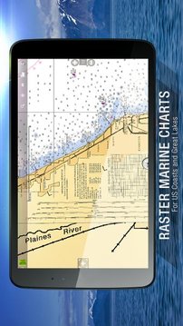
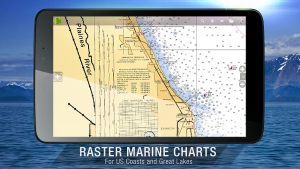
Marine maps: NOAA RNC Nautical Charts (coastal)
USGS Color Aerial photography
Topographic Maps of Spain and Italy
Topo maps of New Zealand
Japan GSI maps.
Many of the above sources are generally free to use.
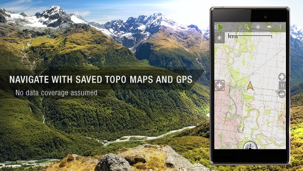
Use offline topo maps and GPS on hiking trails without cell service. The GPS in your Android phone can get its position from GPS satellites, and you don’t have to rely on your data plan to get maps. Have more fun and safe GPS navigation in the backcountry.
Use as a geocaching navigator by getting a pocket query as GPX.
Besides geocaching, use GPS for recording tracks and GPS waypoints on your trip, all the while tracking your GPS quest on topographic maps. It may replace your Garmin handheld GPS.
Here are some of the outdoor GPS activities BackCountry Navigator has been used for:
As a hiking GPS both on hiking trails and off trail.
Camping trips to find that perfect camping site or the way back to camp with GPS.
Hunting trips for hunting wild game in rugged areas.
Doing recon for a hunt or as your hunting GPS
Fishing: make it your fishing GPS.
Search and Rescue (SAR).
Trekking the Pacific Crest trail or other long term hiking.
Kayak and canoe treks on inland lakes and streams or marine, coastal waters.
Backpacker trips: using topo maps of wilderness areas and national forests for navigation on trails with the GPS in your rucksack or backpack.
Find your own ways to have fun in the outdoors. Be a maverick by venturing beyond cell service boundaries with your GPS. Become a pro at navigation with GPS for the outdoors.
BackCountry Navigator has been on WM devices and preloaded on the Trimble Nomad outdoor rugged device. This Android version is more flexible, featured, and fun. Create a memory with maps.
For a one time fee, this a great addition to the outdoor gear you bought at Cabelas, REI, or another outdoor store. Many have found the Android GPS in a phone or tablet to substitute for a Garmin GPS or Magellan GPS, such as the Garmin GPS units Montana, Etrex, or Oregon. Android can be your handheld GPS.
用于脱机户外导航下载地形图!用你的手机或平板电脑作为一个越野地形测绘手持GPS与最畅销的户外导航应用为Android!探索超越小区覆盖远足和其他娱乐。
提前下载地形图,美国和其他许多国家,这样你就不会需要小区的覆盖范围进行导航。使用存储内存映射。
新:Android Wear的支持,看导航在手腕上一目了然
使用GPS航点从GPX或KML文件,或使用经度/纬度,UTM,MGRS或栅格参考输入自己的坐标。使用GOTO使得航点轨迹进行导航。
这将使用许多公开可用的地图资源免费下载。可作为一些额外的内容在应用程序内购买:
-Accuterra地形地图来源为19.99美元/年。这可以购买和使用或在代替游离源使用。
- 数字地球认购允许高分辨率卫星图像脱机存储世界大部分地区。
- 区域分界地图12从土地管理局(BLM)覆盖的价值被猎人地形图的局西部各州。
在一些国家-GMU界限
-Lake轮廓在几个州。
从美国TrailMaps包括-content:
-ATV,白水和马术步道地图
参见下更多 - >“购买附加元件”菜单。它们可以显示在地形地图顶部。
您可以尝试的DEMO版本,以确保您想在贵国的地图。
关于地形(地形)地图:地形地图显示的地形,通过颜色和轮廓,并进行导航越野有用。地形地图和GPS,可用于登山,狩猎,皮划艇,雪鞋,及背包客步道。
您可以用手机阿特拉斯造物主创建自己的地图,或指定一个自定义瓷砖服务器。内置的来源包括:
从MapQuest的OpenStreetMaps
OpenCycleMaps显示全球地形
从Caltopo和USGS美国地形地图
USTopo:航空摄影用标记。
从Toporama加拿大地形地图
海洋地图:NOAA RNC海图(沿海)
USGS彩色航空摄影
西班牙和意大利的地形图
新西兰地形图
日本GSI地图。
许多上述来源通常免费使用。
使用脱机地形地图和GPS对远足径没有手机服务。在你的Android手机的GPS可以从GPS卫星获取其位置,你不必依靠你的数据计划获得地图。有更多的乐趣,并在穷乡僻壤安全GPS导航功能。
通过得到的口袋查询作为GPX使用的寻宝导航。
除了寻宝,利用GPS记录你的旅行轨迹和GPS航点,所有的同时跟踪您的GPS追求的地形图。它可以代替你的Garmin手持式GPS。
下面是一些在室外的GPS活动野外导航已用于:
作为一名登山GPS无论在远足径和关闭跟踪。
宿营找到完美的露营地点或方式回到营地GPS。
狩猎旅行在崎岖的地区猎捕野生游戏。
做侦察的狩猎或你的狩猎GPS
钓鱼:使你的钓鱼GPS。
搜索和救援(SAR)。
徒步太平洋翠园步道或其他长期徒步旅行。
独木舟和内陆湖泊和溪流或海洋,沿海水域独木舟跋涉。
背包旅行:使用荒野地区和国家森林地形导航地图上的小径,在您的背包或背包的GPS。
找到你自己的方式来获得乐趣,在户外。是一个特立独行的冒险通过细胞外服务边界与你的GPS。成为一个职业,在导航与GPS的户外活动。
穷乡僻壤导航仪一直在WM设备和预装在Trimble游牧人户外坚固耐用的设备上。这个Android版本更加灵活,功能和乐趣。创建映射内存。
对于一次性费用,这是一个很好的补充,你买在坎贝拉,REI,或其他户外店的户外装备。很多人发现了Android GPS在手机或平板电脑来代替一个Garmin的GPS或麦哲伦GPS,如Garmin的GPS设备蒙大拿州,的eTrex,或俄勒冈州。机器人可以成为你的手持GPS。


网友评论更多