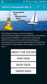
The NOAA Chesapeake Bay Interpretive Buoy System (CBIBS) "smart buoys" collect and transmit real-time weather and water data. CBIBS supports the use and management of a healthy Chesapeake Bay by providing the data and information needed to improve safety, enhance the economy, and protect the environment.
NOAA的切萨皮克湾解说浮标系统(CBIBS)“智能浮标”收集和传输实时的天气和水的数据。 CBIBS支持一个健康的切萨皮克湾的提供,以提高安全性,提高经济性,以及保护环境所需的数据和信息的使用和管理。
NOAA Smart Buoys更新内容
Version 15:
The new NOAA Smart Buoys app works on tablets and smartphones and lets you use data from the NOAA Chesapeake Bay Interpretive Buoy System (CBIBS) to create your own custom graphs. Now you can choose your buoy from a Google Maps setup, too. And the app gives you easy access to more information about each CBIBS buoy’s location.
Version 15 includes bug fixes with Application Preferences, corrects links to Partners pages and performance enhancements to the auto-rotate function.
网友评论更多